
Discover innovative solutions to streamline operations, reduce costs, and elevate your decision-making with cutting-edge aerial imagery solutions.
Targeted access. Transparent pricing.
Smarter Aerial Data, Built for Everyone
Why pay for imagery of places you don't need? Spexi delivers targeted aerial data up to 200x faster than traditional methods, with 30x higher resolution than satellites, for unparalled precision.
30x higher resolution than satellites
50x more cost efficient
200x faster than planes
5M+
Acres
Sub 3cm image resolution
200+
Municipalities
The world’s largest drone imagery network
160,000+
Flights
The first “Fly-To-Earn” network
From Request To Delivery
How Spexi Works
Spexi leverages software and a global network of drone pilots to produce fully standardized and ultra-high resolution imagery products of Earth.
Access Coverage Instantly
With current coverage in 200+ cities, the Spexi World Viewer empowers you to seamlessly access high-resolution, on-demand aerial imagery.


Request Updated Data
Don’t see your area of interest? Simply request a data refresh and your request is instantly routed to our pilot network, with updated imagery typically available within 24 hours.

Get Your Data, Your Way
Access your imagery through the Spexi World Viewer, integrate via our APIs, or export into your own workflows using ESRI-compatible tools.
Two Products to Access Standardized, On-Demand Aerial Data
Access Imagery, Your Way.
Explore high-resolution aerial imagery through our browser-based World Viewer or plug directly into your workflow with our API.
Spexi World Viewer
Panoramas, Seamlessly Stitched - Explore your city with high-res 360° panoramas. No coding, plugins, or manual steps required. A built-in mini map lets you easily navigate between areas - like Google Street View in the sky.
Web-Based and Ready to Go - Access the full Spexi World Viewer from any browser. No software installs needed. It’s fast, intuitive, and always up to date.
Collaborate Without the Friction - Share imagery with stakeholders instantly. Our built-in tools let you link to specific views or projects without requiring new accounts or complicated permissions.


April 13 2025
May 25 2025
Time Series Comparison
Scroll through time to see how your area has changed. Perfect for spotting new builds, tracking encampments, or post-catastrophe imagery.
Smart Bookmarking
Pin key locations for quick access—track important zones over time without digging around.
Enhanced Search
Find what you need faster with location auto-suggestions, recent searches, and smart filters.
Spexi APIs
For enterprises and distributors who need coverage at scale. Our APIs give you fast, flexible access to high-resolution aerial data.
Instant Access to Aerial Data - Query and retrieve high-res aerial data in real time, complete with flight and camera metadata for deeper context and analysis.
Powerful Filtering and Precision Targeting - Filter by location, pitch, heading, altitude, time, and more - enabling highly specific data pulls for your exact use case.
Automate Imagery Access - Set up workflows to pull new imagery as soon as it’s available. No manual steps. No lag. Just continuous data delivery.
Developer-First, with Geospatial Foundations - With modern standards like OGC API - Features and rich EXIF/XMP metadata, our API offers a seamless developer experience today, and is built to enable future integration into geospatial tools and workflows.

Satellite imagery gave us the big picture Spexi gives you the actionable one.
Big picture isn’t enough when decisions need precision. Spexi equips teams with sharper, faster, and more usable data right when they need it.
Resolution
Spexi
Satellite
Crisp detail at ground level, sub-3-cm resolution
15 cm best-case; often 1–5 m for regular updates
Refresh Schedule
Spexi
Satellite
On-demand
Months to years between usable images, especially in low-priority regions
Speed
Spexi
Satellite
Rapid deployment: Get imagery within a couple days
Slow, cumbersome, and laborious. Tasking takes weeks or months
Capture Flexibility
Spexi
Satellite
Operates under most conditions, exactly when needed
Limited by orbit timing, daylight-only passes & cloud cover dependent
Carbon Footprint
Spexi
Satellite
Low: Battery-powered drones, no launches required
High: Requires rocket launches, energy-intensive ground ops
Licensing
Spexi
Satellite
Transparent usage: Built for operational use
Restrictive: Usage rights often unclear; sharing/publishing requires extra fees

Our Success Stories
Government, insurers, AI companies, and infrastructure teams all rely on Spexi to unlock new value from aerial data. Explore how we’re helping them move faster, work smarter, and see more.

"Using Spexi's imagery has reduced field visits, streamlined planning, and improved service delivery."

Cheryl Trent
Data Services & Analytics Manager,
City of Kelowna
City of Kelowna

"Spexi was truly the only option."

Mitch Bate
Head of Geographic Services, Sooke

"With Spexi, I can log in and immediately access fresh aerial data to help plan operations efficiently."

Bruce Briglia
Program Manager at Airspace Link
How Spexi Helps Organizations Innovate
From zoning and development to disaster response, infrastructure inspections to property assessments Spexi gives your team the visibility they need to act faster, spend smarter, and deliver better outcomes.
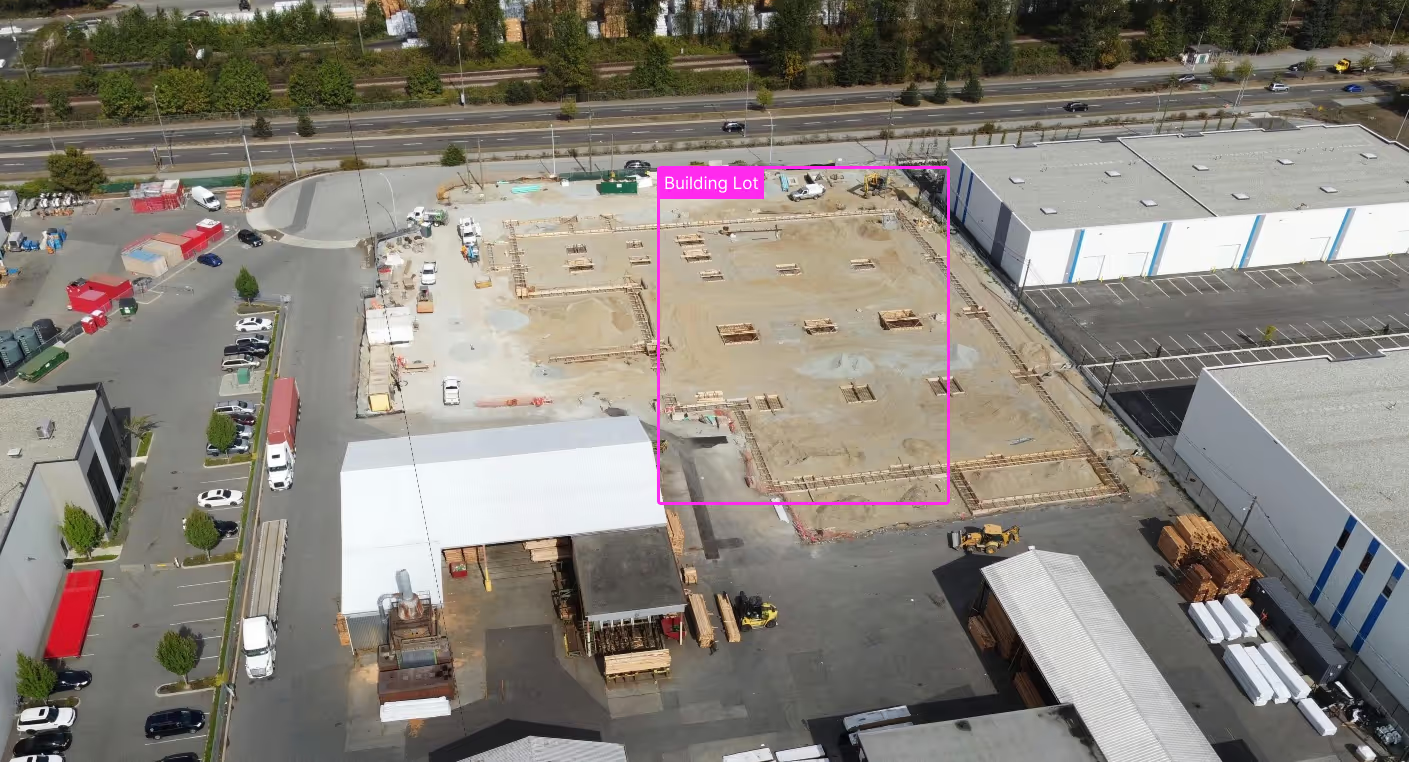
Urban Planning & Development
Outdated maps and slow surveys stall projects before they start. Spexi's high-resolution imagery delivers on-demand, centimeter-accurate data—giving your team a real-world, 3D view of zoning, terrain, and land use.
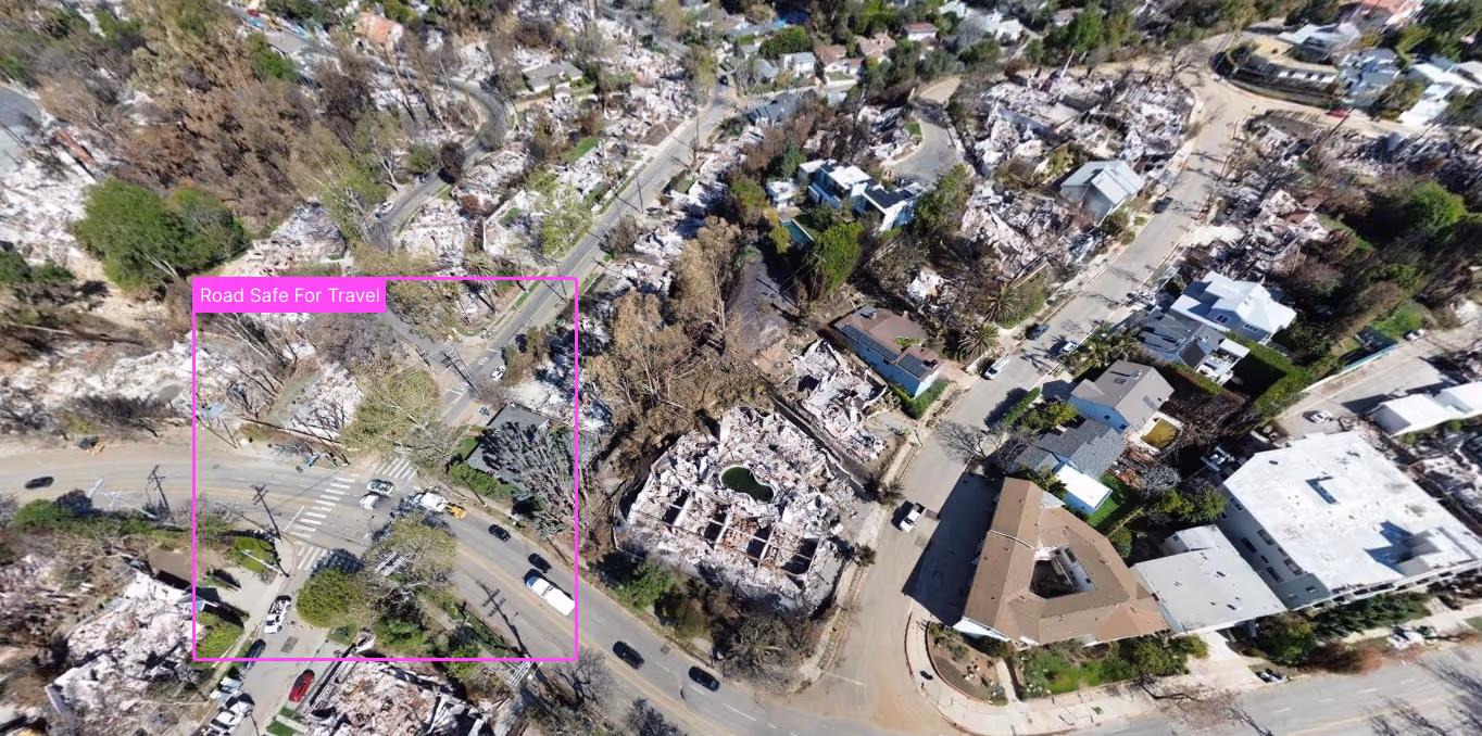
Emergency Management & Public Safety
Disasters demand speed. Traditional response teams often fly blind in the early hours due to poor visibility, blocked access, or limited comms. Spexi's on-demand capture provides situational awareness within hours—mapping damage, guiding responders, and reducing risk to human personnel.
Infrastructure & Asset Management
Manual inspections eat time and budget. Spexi imagery captures detailed imagery of roads, bridges, utilities, and facilities without shutting them down. Detect cracks, corrosion, and vegetation encroachment early, and move from reactive fixes to proactive maintenance planning.
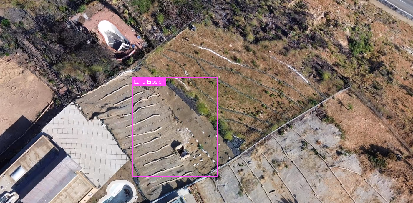
Environmental Monitoring
Manual sampling and field inspections can’t scale across large parks, waterways, or protected areas. Spexi’s imagery enables change detection over time, flags violations quickly, and keeps sustainability goals on track—with less manpower.
Property Assessment & Taxation
Hidden home additions and unreported changes lead to tax revenue leakage. Spexi imagery reveals what’s really there—decks, sheds, pool installations, roof upgrades—without sending someone door to door. Assessments stay accurate, fair, and defensible, improving compliance while reducing costly field visits.
Get the imagery you need when and where it matters.
Thank you! Your submission has been received!

